TA-54 Station Description
- Alternate Name(s)
- Measurements
- Site Description
- Location and Elevation
- Data Quality
General Remarks
Wind Variables
Atmospheric State Variables
Precipitation-related Variables
Radiative Energy Variables
Alternate Name(s): White Rock
Measurements:
The TA-54 station consists of a 46-m tower instrumented at three
levels for wind and temperature and near-surface instrumentation for measuring
temperature, moisture, precipitation, and radiative fluxes.
See Table 13.4 in the Meteorological Monitoring Plan for measurement details and Table 13.3 in the same document for definitions of variables.
| Data Type | Record Begins | Record Ends |
| 15-min data | January 29, 1992 | (still active) |
| 24-h data | January 29, 1992 | (still active) |
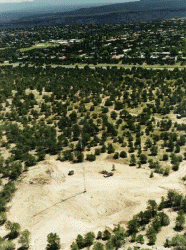
Site Description:
The TA-54 station is located in a clearing just off the eastern tip of Mesita
del Buey on the Pajarito Plateau. The terrain drops 15 m into Canada del Buey
to the north and drops 10 m into Pajarito Canyon to the south. To the
east-southeast, the terrain drops gently about 75 m to the eastern edge of
White Rock Canyon. The view of the station, as shown in the above
photograph, is looking southeast toward the residential area of White Rock.
The eastern escarpment of White Rock Canyon can be seen near the top of the
photo. Since construction of the tower, some natural vegetation in the
form of low growing shrubs have returned to the area around the tower.
Post-Cerro Grande fire cleanup activities and the early 2000 drought and pinon
beetle infestation has eliminated most of the trees in the area although the
dead trees are still standing.
Beyond the clearing, pinon and juniper trees of 2 m height cover a most of
the surrounding area. The plateau tilts at about 1.5 degrees to the
east-southeast in the vicinity of this station.
| Coordinate System | x | y |
| NAD 27 State Plane Coordinates (ft) | 508073 | 1755793 |
| UTM, Zone 13 (m) | 389497.91 | 3965317.19 |
| Longitude & Latitude | -106° 13' 23.9" | 35° 49' 32.8" |
Station elevation is 6548 ft (1996.3 m) above sea level.
The tower is LANL structure no. TA-54-0088, and the datalogger shed is LANL structure no. TA-54-0169.
General Remarks:
For the most part, all suspect data have been replaced with an asterisk (*).
Occasionally you will see days on which all the 15-min data appear good, but
some of the 24-h summary values are missing. Lightning strikes, momentary power
outages, or the need to reload the datalogger program may be the cause. In
these cases, you can estimate a 24-h value from the 15-min data.
See Section C.1.b and c of the Meteorological Monitoring Plan for details on sampling and general remarks concerning accuracy.
Qualifying remarks are organized by data type (for example, wind, atmospheric state, etc.), and we use our standard variable names, as defined in Table 13.3 of the Meteorological Monitoring Plan.
Wind Variables:
For the most part, all suspect data have been replaced with an asterisk (*).
Occasionally you will see days on which all the 15-min data appear good, but
some of the 24-h summary values are missing. Lightning strikes, momentary power
outages, or the need to reload the datalogger program may be the cause. In
these cases, you can estimate a 24-h value from the 15-min data.
See Section C.1.b and c of the Meteorological Monitoring Plan for details on sampling and general remarks concerning accuracy.
Qualifying remarks are organized by data type (for example, wind, atmospheric state, etc.), and we use our standard variable names, as defined in Table 13.3 of the Meteorological Monitoring Plan.
Atmospheric State Variables:
Occasionally one encounters relative humidity (rh) values exceeding
100%; we recommend changing these values to 100%.
Precipitation-related Variables:
No known problems.
Radiative Energy Variables:
During and for some time after periods of snow or frost formation, the
domes of the upward looking pyranometers and pyrgeometers may become snow or
ice covered. In such instances the shortwave irradiance (swdn) is diminished,
and the long-wave atmospheric irradiance (lwdn) is greater than it should be.
Our editing has not been consistent: In portions of the record we attempted to
remove these snow and frost effects and in other portions we decided not to
edit. In general, it is difficult to decide when the melting is complete and
the signal is back to normal. Because swdwn and lwdn are used in the
calculation of the net radiation (netrad), netrad is also affected.
As a result of a change in the calibration standard used by the manufacturer, measurements of swdn and swup are 5% too large from the beginning of the record to April 5, 1995 at 1045 MST.
During the daytime, lwdn may be over-estimated by an amount equal to 2.7% of swdn because of heating of the dome (see A. D. Culf and J. H. C. Gash, "Longwave Radiation from Clear Skies in Niger: a Comparison of Observations with Simple Formulas," J. Appl. Meteor., 32, 539-547, 1993).